


Triona leads the way for Oslo Municipality
In summer 2021 Triona started a project together with Oslo municipality when the municipality wanted better support for planning, prioritization, and budgeting of road and street maintenance.
They also wanted to draw up a plan for how the road maintenance backlog should be handled. Triona's first task was to create a digital overview of the status of the road network throughout the Oslo municipality. Triona's SINUS and TNE products were used and the assignment was carried out together with Triona's collaboration partners EyeVI and Veiteknisk institutt (Road Engineering Institute).
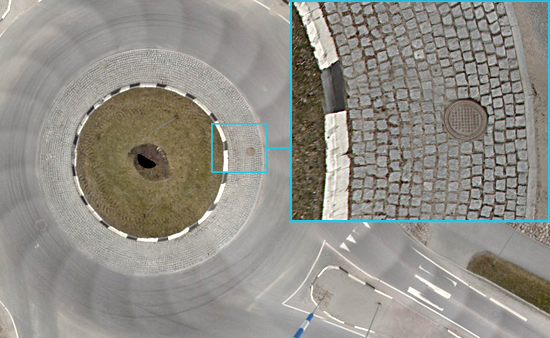
An example of an orthophoto from a roundabout showing high resolution and detailed zoom-in.
A 360 degree start
Triona started the assignment by taking 360° panoramic photos and laser scanning Oslo's complete road network, including pedestrian and cycle paths, a total of 1,365 km. Both the 360° images and lidar data were measured using high-precision GNSS equipment with CPOS correction.From this, high-resolution orthophotos were generated, which were then used as a reference map for further work. The reference maps can also be used in other contexts, e.g. when planning construction projects, in traffic planning and management.
”With a maintenance plan for the Oslo municipality's roads 2022-2031, which is based on correct data in NVDB, we have prerequisites to make the best decisions going forward. Oslo municipality's goal with the project was to get an updated status regarding the road network and to be able to predict the need for the resources required from both the road manager and the authorities that grant funds. We have succeeded in that! And, through automatic identification of damage in the pavement, based on 360˚ panoramic images and lidar data and AI (Artificial Intelligence), we have gained a knowledge of the state of the pavement that is completely unique” Joakim Hjertum, Section Manager Bymiljøetaten Road Operations and Maintenance
AI for data extraction
In step two of the assignment, Artificial Intelligence (AI) was used to extract road-related data from the panoramic images. Lidar data was used to provide sufficient position accuracy, between 10 and 100 cm depending on the environment. Using Triona's SINUS product, with support for 360° images and orthophotos, all objects were registered and supplemented with information from other systems as well as data not captured by the AI process. All image storage was done in Microsoft Azure. The workflow provided a good and efficient working environment where time spent in vehicles and out in the field was minimized, resulting in both lower environmental impact and less traffic disruption.
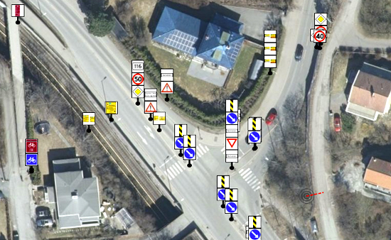
Traffic signs that are automatically registered .AI from the 360 images.
Updated and verified data in NVDB
All data and information generated in the project is stored in the NVDB, National VegDataBank. The data already stored in NVDB was verified and supplemented with new and updated data. Examples of data types that are registered are pedestrian zones, rails, fences, traffic signs, information signs, road markings, traffic calming devices, lights, road surface and width of the road. In addition, the actual condition of road signs, rails and surfaces is registered.
”Triona's solution is exciting and has made a tangible difference to Oslo’s streets and roads. It is a great example of how to use Microsoft Azure to work innovatively and securely with a city's infrastructure. I am convinced that other municipalities will look at this as inspiration for their businesses” Therese Treutiger, Director Global Partner Solutions & Innovation, Microsoft Sweden
Road maintenance master plan for the next 10 years
The assignment concludes with the drafting of a road maintenance master plan with a planning horizon of 10 years (2022 - 2031). Some of the most important parts of the master plan are documentation of the road maintenance backlog and a calculation of the resources required to clear the backlog. The master plan also includes a definition of the desired road standard and what is required by budgetary frameworks for operation and maintenance to ensure the standard is met. Proposals were also drawn up for an action plan to rectify the backlog, an action plan that will be adjusted during the planning period as actual budgetary frameworks and policies take effect.
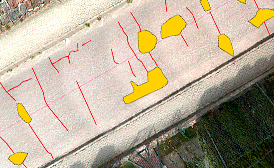
Damage to the road surface can be longitudinal or transverse cracks, etc. Everything is visualized in SINUS as surfaces or lines as shown in the image.
Customer: Oslo Municipality
Industry: Transport infrastructure
Problem: Lack of support for planning, prioritization, and budgeting for street and road maintenance as well as how planning for the road maintenance backlog should be handled.
Solution: Create a digital overview of road networks and associated objects in Oslo municipality and develop a Master Road Plan (maintenance and action plan) for the next 10 years.
Keywords: : #AI #digitaltwin #lidar #transportinfrastructure #360°roadphotos #SINUS #TNE #NVDB
